| © 2008 by SourceSink consortium - all rights reserved |
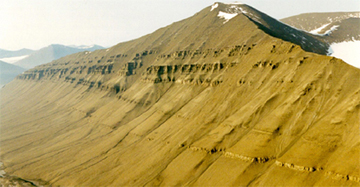
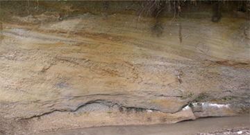
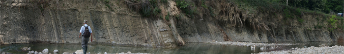
Connecting sedimentation across basin gateways: (Top Left) Seismic-scale clinoforms connecting shallow to deepwater environments, along the mountainside of Storvola, Spitsbergen; (Top Right) Alluvial/deltaic deposition during Miocene in Dacic Basin, Romania. (Low) Turbidite Miocene deposits cropping out along Ramnicu Sarat Valley, Dacic Basin, Romania. In top right photo the outcrop is 3m high. Storvola Mountain is 1000m high
Brief description (details available by contacting dr. Cornel Olariu)
The project is focused on (1) the architecture and (2) sediment-volume partitioning of the Neogene sedimentary deposits in Dacian basin. Of special interest is the timing of infill, the particular architecture of this closed basins and the sequence stratigraphic models that arise from these datasets are all of great interest, particularly as regards the Dacian and adjacent Pannonian and Black Sea Basins.
Currently, the deposits of these closed basins (lakes) are studied according to the sequence stratigrapic paradigm that was developed for marine basins. This approach is not appropriate for closed basins because relative base-level change and sediment supply are closely linked, and are in phase, unlike marine basins.
The specific key questions related to sediment partitioning in this type of basin are (a) how are the sediment volumes partitioned between shelf, deepwater slope and basin floor within a closed basin during a base-level cycle? (b) will the high rates of base level change lead to particular architectures e.g., will deltas have time to establish as distinct ‘bodies’, or will there simply be widespread sand sheets? (c) will the basin floor (base of clinoform) aggrade with turbidites abnormally rapidly because of the frequent hyperpycnal floods? (d) is the same geometry observed in all isolated basins or are there coeval architectural differences given by the particular base-level rates, supply and salinity in each basin?
The project is a detailed study that will focus on the architecture and controls for the Dacian Basin infill. However, we aim to understand the importance of the main controls for the closed basins and produce a general model that can also be used for adjacent basins.
Meanwhile the geographical position of Dacic basin between the Panonian and the Black Sea allow us to evaluate the sediment transfer at regional scale. The sedimentary architecture of the Dacian basin will also help understanding the connection and sediment transfer between Dacian and adjacent basins, the possible sequential infill of the basins, and location and the size of the main sediment paths (like Paleo-Danube river).
The main data to be used are well log measurements. Dacian Basin has thousands of wells because the area is a mature oil province. The well logs will be combined with seismic and outcrop data.
Sedimentary description of the oucrops will be used to establish the sedimentary depositional environments and to establish the typical bedding geometries. Neogene deposits of the Dacian basin are cropping out on most of the river valleys that are draining the southern Carpathians. Despite outcrops having continuous exposures of vertical succession for hundreds of meters, the outcrops have relatively poor lateral continuity. To understand lateral variation of the deposits we will use well logs that have a good (submeter) vertical resolution. The density of well logs in the basin is high because of the intense exploration and exploitation. The larger basinal-scale picture will guide our well log interpretation, and regional seismic acquired in the basin will be used.
|