| © 2008 by SourceSink consortium - all rights reserved |
t
Problem statement: Understanding of the relationships among processes relevant to sediment production, transport, accumulation, and preservation on margins at multiple temporal and space scales, from turbulence to tectonics and from sedimentary fabric to sequence stratigraphy and basin analysis.
Aims and objectives: An expected outgrowth of the project is enhancement of the ability to quantitatively interpret the stratigraphic record of change in both terrestrial and submarine settings. This will allow for a notable extension of the record of environmental change affecting human populations and ecosystems along continental margins.
Here especially, we will address the study of the Active sink of the system, The IP will focus on the areas of active deposition which are essentially controlled by climate variability, sea level variation, sediment balance and neotectonics. In consequence this Individual project will address the history of sedimentation; the (neo)tectonic framework and the development of eustatic levels in the Late Pleistocene in the Black Sea.
Innovation: The study of the active sink in the frame of the Source Sink project will give a good example of the functioning of one of the most important drainage and receiving basin of Europe (Aksu et al., 2002a; Aksu et al., 2002b; Degens and Ross, 1974; Ryan et al., 2003). Actually, the north-western Black Sea receives the water and sediment discharges of the largest European rivers (Danube, Dniepr, Dniestr). During the glacial lowstands and especially at the beginning of interglacials, the sediment discharges of these rivers were probably much higher (Lericolais et al., 2007a; Lericolais et al., 2007b; Panin and Popescu, 2007). The examination at an appropriate scale of sediment path ways dispersion across the continental shelf towards the slope and the deep sea zone and then of their deposition, compaction and/or possible sliding represents a case study for deciphering the inout of sediment loads and water fluxes produced during the melting of the ice after the deglaciation. The Danube system is the pathway of the melting produce from the Alps and the Black Sea the end member.
Beyond the continental shelf is a complex system of canyons, channels, accumulative sedimentary bodies leading to deep-sea fans (Popescu et al., 2004; Popescu et al., 2001). The Danube deep-sea fan which can be considered as a potential hydrocarbon field, developed in the north-western part of the Black Sea from sediments fed by the Danube but also by the northern rivers: the Dniepr, the Dniestr and the Bug (Popescu et al., 2004; Winguth et al., 2000). It extends for about 150 km downslope of the shelf break, and the distal end of the fan reaches the abyssal plain at 2200 m water depth. Depositional processes are located essentially on the middle and lower slope. Recent and further contributions will improve considerably our understanding of the architecture and growth pattern of the Danube and Dniepr deep-sea fans (Popescu et al., 200).
Added value: A major goal of the project aims to approach the natural hazard analysis of active mountain and drainage systems in a novel way through the step-wise, quantitative reconstruction of sediment mass transfer. In this IP this will be done through integrated studies on the sedimentary processes and sequences since the last Quaternary period of the western Black Sea margin. The Black Sea is a unique laboratory in the world and this proposed project represents a case study for a better understanding of sedimentary processes in a semi-enclosed anoxic receiving basin.
This IP project within the SourceSink project will shed light on sedimentary aspects and will improve through multidisciplinary margin research our understanding of :
- Quaternary evolution of the Black Sea margin;
- Water and sediment river input and their linked sedimentary processes from the prodelta down deep to the Deep Sea fan.
Methodologies/experiments: The project proposed here combines various expertise on continental shelves ranging from geophysical mapping to ground truth verification by core analyses and age dating of sediments. Ifremer partner has already got experience in studies of the north western Black Sea shelf and its linked deep-sea fans. Through it established partnership and in link with other Individual projects within the SourceSink leadership, this project will contribute to a dedicated interpretation of detailed images of seafloor provided by swath bathymetric mapping, very-high-resolution (VHR) seismic and High Resolution Multichannel seismic imaging, and ground-truthing by core interpretation. Ifremer possesses already a wide range of such data and propose to focalise project studies in the direction to solve the question posed in the previous paragraphs.
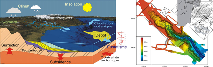
(Left) The SourceSink concept applied to the deep sea fan deposition of the major discharges in the western Black Sea basin; (Right) Topography of the Danube deep sea canyon, the sedimentary pathway towards the deep sea fan (Popescu et al., 2004)
Work plan: Ifremer will coordinate the studies and integration of the understanding of the "Active Sink", in providing study results on areas of active deposition and in confronting these results with the processing factors such as: sea level variation, sediment balance and neotectonics. In addressing the history of sedimentation; the (neo)tectonic framework and the development of eustatic levels in the Late Pleistocene; Ifremer participation will be a end member of the Sourcesink network providing the information on the sink of the system. The results will be used by Sourcesink partners to integrate these information into the ongoing project modelling linking tectonic and drainage pattern to sedimentary processes facilitating the understanding of the sedimentary transport evolution. This will be also linked to climate modelling studies from past proxies to reconstruct and model major trends in system evolution; modelling of sedimentary basins evolution in active time frame with inferences on drainage patterns.
Ifremer will be a key proponent in providing information on the end-member stratigraphic record. It is well known that this record is one of the main source providing information about the history of the Earth's surface, as well as the repository of major reserves of groundwater and hydrocarbons. If we can deconvolve the record correctly, we can reconstruct the history of sea level, climate, and tectonics. But the fidelity of the stratigraphic record is imperfect; often distorted and contains gaps over a wide spectrum of time scales. Our reconstructions of past events are only as good as our understanding of how they are recorded in sediments. And our ability to find the next generation of sediment-hosted resources will be limited by our ability to predict the locations of potential reservoir bodies in the subsurface. Understanding the formation of the stratigraphic record is truly a source-to-sink problem, from the generation of the signal carrier (the sediment) to the partitioning of fluxes among the whole suite of margin environments. Integrated studies of sediment production and archiving for a time interval for which key controls (e.g. sea level) are relatively well understood is a crucial step toward developing reliable interpretive and predictive stratigraphic tools.
|

