| © 2008 by SourceSink consortium - all rights reserved |
Problem statement: Anoxic basins are of large interest to oceanographers of all disciplines. Their extreme conditions result from combination of high oxygen utilization and restricted circulation. The understanding of present-day anoxic environments is crucial for the early evolution of the oceans.
The modern Black Sea has been considered as the type-location for anoxic basins. It is semi-isolated from the remainder of planetary oceans. Only the narrow and shallow Bosphorus Strait provides water exchange with the Mediterranean. Concentrations of hydrogen sulfide reach values of 350 Mm in the deep water and oxygen-hydrogen sulfide exists between 80 and 200m water depth. The Bosporus (Strait of Istanbul) and its sills located at the northern and southern exits have the ultimate control on this connection, regarding to global sea level changes and regional climatic conditions in semi closed Black Sea. This particular confluence, including the sill lied within the channel, and the extension of the Bosporus channel into the Black Sea shelf is a key to understand the natural processes occurred in the recent geological past.
Two main wavelengths can be defined in relationship with the (near) Bosporus connectivity, a short-wavelength effect related to water exchanges and a long-wavelength effect related to generalised changes in environmental conditions. The later can be observed in the far-field influences on the geometries of deltaic bodies such as Danube or Dniepr, while the combined effect can be observed near Bosphorous.
|
Structural patterns at the entrance of the Bosphorus Channel. |
The main project problem statements are:
- quantification of sedimentological processes given by Bosphorous water exchanges, in particular during the moments of opening/closure of this gateway towards the Mediterranean. This will be obtained by eliminating the long-wavelength effect from the combined one.
- forecasting sedimentological processes conditioning the future evolution of the Bosphorous strait (and consequently down to Mediterranean) though a comparative study with the Paratethys gateways.
Two conditions are required for these problem statements: a) combined effort in a suitable research environment, i.e. international, crossing the many Black Sea and Paratethys national borders and b) collection of new and high resolution data able to provide focussed and comparable information over the connectivity with the Mediterranean AND the Danube Paratethys basins.
Aims and objectives: The hydrographic regime is characterized by low salinity surface water of riverine origin overlying high salinity deep water of Mediterranean origin. A steep pycnocline is the primary physical barrier to mixing and is the origin of the stability of the anoxic interface. The depth of this interface reflects the balance between fresh water and salt water inflows and may be precariously sensitive to changes in neither.
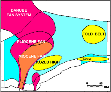
The current terrigenous sediment input is estimated to exceed 1000 million tones per annum, 80 million tones from the Danube alone. Deep water terrigenous sedimentation is restricted areas by channels and other processes of submarine fan development. Pelagic sedimentation plays the major role in the deep basin of the Black Sea, far exceeding the amount of sediment supplied by rivers. The total abyssal sedimentation rate is about 10cm 10-3 yr. These sediments are rich in calcite and organic carbon, the latter showing a high degree of preservation due to the waters below 80-120m. Methane seeps are a common feature around the basin; the mud volcanoes have been identified. It has been suggested that shelf and slope sediments of high deposition rate are methane sources, whereas the basin is a methane sink. Turbidites are common features of cores taken in the Black Sea, particularly those recovered from the abyssal sediments in the western basin.
The source of energy required turbidite flows is unknown, but three possible agents are methane production and earthquakes, both of which lead to sediment instability and slope failure and oversteeping of delta fronts. In this respect the development of the Danube delta fan is very important (because the Danube supplies about 80 % of the clastic sedimentation in the Black Sea basin.
The Black Sea basin is lying towards the northern margin of the group of orogenic belts related to the closure of the Tethys Ocean (backarc position), it is generally considered to be a result of back-arc extension associated with northward subduction of the Tethyan plate. The onset of the Black Sea extension took place in Albian times, but since the late Eocene the basin is undergoing mostly compression, as a result of the generalised inversion still widely observed on the northern and southern flanks. One interesting issue is the mechanism for the apparent co-existence in time of the Upper Miocene shortening recorded on the northern (Crimeean) and southern (Turkisk) side with the extension observed near the structural axis of the basin (offshore Romania). This potential contradiction yields different mechanisms for the coeval large-scale landslides observed in the basin, as an analogue for potential present-day natural hazards.
The main aspects should be tackled are:
- The influences of tectonics and depositional/erosional events on the continuation-extension-termination of the Bosporus channel in the Black Sea shelf, in particular during the moments of connection opening or closure.
- The origin and sedimentary evolution of the northern shallow sill.
- The records of sea level changes and water exchanges.
- Comparative analysis of the sedimentological architecture between Danube/Dniepr delta/deep sea fans and present day accumulation near the Bosporus.
- Comparative analysis of the erosional patterns in the Bosphorous strait and those observed during moment of basin piracy in the South Carpathians or Danube Delta gateways.
Innovation:
- Comparative studies between former, deltaic and marine gateways are of currently high scientific interests, owing to climatic change effects. In particular, the current debate on catastrophic (or not) flooding events such as the ones speculated during the Hollocene in the Black Sea (e.g., Ryan et al., 2003) are of high human impact.
- This confluence has the records and evidences of the mechanisms and history of the connection of the Bosporus to the Black Sea. This is also of critical importance in explaining the origin of organic-rich sappropels and sapropelic layers deposited in the Eastern Mediterranean regions. Since no such detailed study has been carried out at this confluence, this project will provide new evidences and information to the available contradictory views.
- To determine the structural features and causative elements at the Bosporus and combining the previous available data from the rest of the Bosporus channel will clarify the origin and opening mechanism of the Bosporus, in connection with the activity of the Northen Anatolia Fault Zone. This is valid in particular through comparing with particular the alternative hypothesis of regional low- and high-stand events developed inside this CRP.
- This research will also provide exchanging information and cooperation between scientists and researchers from the European and the Black Sea countries focussed on training young researchers/scientists.
- Gas hydrates in marine sediments may comprises the largest hydrocarbon reservoirs on earth, Huge amount of methane are stored in hydrate deposits in continental margin sediments and release of this potential greenhouse gas can play a key role in climatic change, the flux gas from methane deposits can be related to tectonic activity on downwelling slab and destabilized hydrates on continental slopes may produce megaslides and causes tsunamies on densely populated coastlines. Decomposition of hydrate and hydrate-related processes are significant source of carbon to the oceans, although the impact of this flux on ocean chemistry is largely unknown. A comparative evaluation of the gaz hydrates development around the Black Sea shelf is interesting for regional evaluation.
Added value: This research will provide better identification of detailed bottom features of the northern entrance of the Bosporus. The project will provide new data to those of scientists in marine sciences, earth sciences and also present supplementary background information for oceanographers, environmentalists, governmental agencies, local and greater-city municipalities, enhance scientific collaboration among scientists of neighboring countries, enhance and ease foreign (civil, political/diplomatic and cultural) relations among neighboring countries. We will discuss the scientific outputs at national and international symposiums, workshops, and seminar series to inform public and as well as relevant governmental offices.
Methodologies/experiments:
High resolution geophysical data sets will be collected comparable with data and their positioning of IP05, IP06, IP07; Drilling and coring will add to the available multibeam data and piston cores sediment samples. The available seismic and multibeam data collected from the Bosporus will be correlated with the ones on the Romanian and Ukrainian offshore.
- High resolution geophysical survey: Available multibeam data from the Bosporus provides important information on the character and morphology of the Bosporus channel. New multibeam data collection will be performed on the BBSC. These data will provide an initial step for determining the bottom depositional and tectonic features and also tracking the channel into the southern Black Sea shelf. High resolution seismic survey will be focused on particularly on the extension of channel and also carried out on the adjacent shelf.
- Drilling: Based on seismic data and piston cores, an appropriate site will be decided for drilling. The criteria for site selection are to drill a borehole representing undisturbed layers on either sides of the channel.
- Laboratory Analysis: Besides high resolution paleontological and sedimentological analysis, age determination will be performed in drilled sediment samples. Drilling results area highly important in recognition of past water exchange events, depositional and erosional events. The sedimentological record will also be used as cross-check with the results of geophysical survey.
Deliverables and/or milestones:
- Sedimentological conditions near the Bosporus strait as a comparison standard for recent evolution of the Danube and Nistru deltaic bodies. Although the research area is a key to understand the role of the Bosporus in the recent geological history of the connection of the two inland seas, no investigation has been carried out at the Bosporus channel in the Black Sea shelf. Therefore the project will provide new high-resolution bathymetry, besides the detailed documentation of sedimentary/tectonics elements at the BBSC. Multi-channel seismic reflection data will be collected using high technology seismic equipment from Dokuz Eylul Univ., Institute of Marine Sciences and Technology (IMST), onboard of research vessel R/V K. Piri Reis. This seismic equipment is capable to collect very high resolution seismic data on the shelf area, which can provide very detailed picture of the stratigraphy of recent (and early) sedimentation, erosional surfaces associated with active channel/canyon systems, possible shallow gas accumulations and unconformity surfaces related to the sea level changes or to the opening of the Bosphorus channel. This kind of high resolution seismic reflection data have never been collected in the area so far. Apart from drilling boreholes in the central part of the Bosporus channel for engineering purposes, no scientific drilling has been carried out in the Bosporus channel. In this sense, this will also be a new attempt. Milestone 1: Processing and Interpretation of the MCS profiles and cores.
- Cartography of the Sediment pathway on the Bosphorus entrance continental shelf of the Black Sea. Milestone 2: interpretation on the seismic of the paleo major incision in the Quaternary on the Turkish Black Sea continental slope and comparative study with the erosional patterns along the Viteaz canyon (Romania) or incisions over the Odessa shelf.
- The Bosphorus entance to the Western Black Sea basin; Late Quaternary deep-sea sedimentation in the western Black Sea; Milestone 3: Interpretation of the multibeam data and seismic data and building the comparative models of evolution.
|


