| © 2008 by SourceSink consortium - all rights reserved |
Problem statement: Sediment cascades in alpine environments are influenced by topography, (neo) tectonics, climate and human impacts and by the interaction between these components. These variables in turn will finally control the magnitude and frequency of geomorphologic processes. An analysis of sediment cascades implies a differentiation of source areas, pathways and (terrestrial) sedimentary sinks (Fig. 1) and is, however, a scale dependent issue (Schrott et al. 2006). Considering relative short temporal scales from a geological point of view (e.g. Late and Postglacial), large parts of areas considered to be source areas may turn into important (temporary) sinks. Reasons for a decoupling of Alpine sediment cascades are valley blocking deposits or oversteepening effects of past glaciations generating significant knickpoints in longitudinal basin profiles (increased sediment storage upstream, accelerating erosion below). Furthermore, many Alpine areas currently shift to “new” source areas due to permafrost degradation (e.g. destabilizing talus slopes) and glacier retreat. This increasing sediment availability is of major importance in terms of natural hazard assessment.
Whereas most previous studies on sediment fluxes in upper catchments focus on small spatio-temporal scales, we intend to apply a nested cross-scaling approach from first to third order basins. Therefore this study will also contribute to a deeper understanding of the paraglacial sedimentation cycles in different sized alpine environments (Church & Ryder 1972, Ballantyne 2002, Harbor & Warburton 1993).
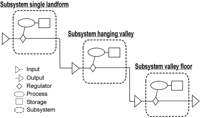
Conceptual model of an alpine sediment cascade (based on Chorley & Kennedy 1972)
Aims and objectives: The main objective of this study focuses on a detailed analysis of the source area. Based on a systems approach, different subsystems of specific sediment fluxes and storages types within the sediment cascades will be identified and quantified (Fig. 1). This requires the understanding of single landforms and landform units that indicate areas of erosion (e.g. source areas of debris flows) and sedimentation (e.g. floodplains, talus systems) (Schrott et al. 2003). In this context, it is of major concern how erosional and depositional processes are related to specific topoclimatic variables and morphometric properties of the surface as well as subsurface features. The outcome of this project will (i) improve the resolution and the knowledge of source area characteristics, and (ii) will contribute to a better understanding of the source to sink linkage of terrestrial sedimentary systems.
Where: The study site is located in the Eastern High Tauern Range (Austria) encompassing a part of the Möll catchment with several tributaries. According to the scale based approach we will disintegrate the study site into several nested subsystems. The selection is based on the following criteria:
- Recent geomorphologic and (neo-) tectonic activity (Southern Alpine Range)
- High variability of geomorphologic processes in terms of sediment flux (solifluction, permafrost creep, rockfall, fluvial sediment transport)
- Extensive preliminary work and long time series of solifluction rates (Veit et al. 1995)
- Excellent accessibility (small cable car up to 2650 m a.s.l.)
- Part of the Danube hydrological system
Innovation and Added value: The project findings will substantially improve the knowledge of the dynamics of the source system, both in the present-day and the Late and Postglacial situation. This implies a modification of the conceptual model about non-glacial processes that are directly conditioned by a former glaciation (paraglacial concept). Based on our detailed studies about the changing ratio between areas and quantities of sediment flux and temporary sinks through Late- and Postglacial times we intend to identify signals (e.g. climate change) as driving forces of the system (Church & Slaymaker 1989, Jordan & Slaymaker 1991, Hinderer 2001).
Methodologies/experiments:
The cross-scaling approach requires a combination of field and modelling techniques:
- Identification and spatial distribution of landforms and processes through orthophoto-interpretation, geomorphological mapping, and morphometric digital terrain analyses
- Quantification of single landform volumes and entire catchment storage (volume/mass) by a combination of a) shallow coring (<20 m), b) field geophysics (ground penetrating radar/ GPR, electrical resistivity tomography/ ERT, refraction seismic tomography/ RST), c) morphometric and knickpoint analyses, and d) the application of the Sloping Local Base Level (SLBL-) model (Jaboyedoff & Derron 2005). The SLBL model uses an algorithm for calculating bedrock topographies of alpine valleys by an iterative procedure using DEM data of high resolution (≤ 10 m).
- Calculation of present-day erosion rates by means of slope process monitoring (incl. repeated terrestrial laser-scanning and continuing a 20-years time series of solifluction rates)
- Calculation of Late and Postglacial erosion rates by coring, sampling and numerous 14C datings
Work plan: The project will be modularly organized with the specification of six working packages (WP 1-6).
- WP 1: Geomorphic field-mapping campaign (incl. orthophoto interpretation)
- WP 2: Slope process monitoring (tachymeter and laser scanning survey)
- WP 3: Field geophysics
- WP 4: Terrain modelling (geomorphometry) and DEM analysis
- WP 5: Inversion and interpretation of geophysical data
- WP 6: Publication and dissemination of results (scientific journals, conferences)

Temporal distribution of the working packages from 2008 to 2010
Deliverables and/or milestones: The main deliverables of the projects are:
- Time series of solifluction rates (>20 years record of horizontal displacement) will be continued and intensified; each year
- 4D topographic slope monitoring (repeated high resolution laser scanning); once each year
- Quantities of sediment storages in Late and Postglacial times, valley cross-sections; will be carried out; first two years
- Estimation of recently developed (so called “new”) source areas (e.g. due to permafrost degradation) in terms of sediment availability as an important prerequisite for natural hazard assessment; second year
- Sedimentation rates in different Alpine sub-catchments; third year
- Ratios of current and Late/Postglacial sediment fluxes and sediment storages across different spatial scales; third year
- Modified conceptual model of paraglacial sedimentation in Alpine subcatchments of different size; third year
- Dissemination of scientific results (journal publications, posters and oral conference presentations); first year onwards
References:
- Ballantyne (2002): Paraglacial geomorphology. – Quaternary Science Reviews 21, 1935-2017.
Chorley, R.J. & B.A. Kennedy (1971): Physical Geography – A systems approach. London.
- Church, M. & J.M. Ryder (1972): Paraglacial sedimentation, a consideration of fluvial processes conditioned by glaciation. - Geol. Soc. Am. Bull. 83, 3059-3071.
- Church, M. & O. Slaymaker (1989): Disequilibrium of Holocene sediment yield in glaciated British Columbia, Nature, 337 (2), 452-454.
- Harbor, J. & J. Warburton (1993): Relative rates of glacial and nonglacial erosion in Alpine environments. - Arctic and Alpine Research, 25 (1), 1-7.
- Hinderer, M. (2001): Late Quaternary denudation of the Alps, valley and lake fillings and modern river loads. - Geodinamica Acta 14 (4), 231-263.
- Jaboyedoff, M. & M.H. Derron (2005): A new method to estimate the infilling of alluvial sediment of glacial valleys using a sloping local base level. - Geografia Fisica e Dinamica Quaternaria, 28(1), 37-46.
- Jordan P. & O. Slaymaker (1991): Holocene sediment production in Lilloet river basin, British Colombia: sediment budget approach. Géographie Physique et Quarternaire, 45(1), 45-57.
- Schrott, L., Götz, J., Geilhausen, M. & D. Morche (2006): Spatial and temporal variability of sediment transfer and storage in an Alpine basin (Bavarian Alps, Germany). – In: Geographica Helvetica, H.3, 191-201.
- Schrott, L., Hufschmidt, G., Hankammer, M., Hoffmann, T. & R. Dikau (2003): Spatial distribution of sediment storage types and quantification of valley fill deposits in an alpine basin, Reintal, Bavarian Alps, Germany. - Geomorphology, Vol. 55, 45-63.
- Veit, H., H. Stingl, K.-H. Emmerich & B. John (1995): Zeitliche und räumliche Variabilität solifluidaler Prozesse und ihre Ursachen. Eine Zwischenbilanz nach acht Jahren Solifluktionsmessungen (1985-1993) an der Meßstation "Glorer Hütte", Hohe Tauern, Österreich. - Zeitschrift für Geomorphologie, Suppl.-Bd. 99, 107-122.
|


