 |
SourceSink |
Danube Basin Geosciences |
 |
|
| © 2008 by SourceSink consortium - all rights reserved |
Problem statement: The main goal of this project is to reconstruct the post-Mesinian evolution of the Black Sea (as the main sink of Central Europe) by analyzing the interplay between tectonics, sea level variations, sediment supply and subsidence, as reflected in the 3D architecture of the Upper Miocene-Quaternary sediments.
Aims and objectives: The presently Black Sea receptacle has an unusually good record of its sedimentary geometry providing a continuous Upper Miocene – Quaternary transition along the north-western shelf and deep sea fans. This semi-enclosed system is very sensitive to limited variations in its boundary conditions, in particular the presently narrow Bosporus connection with the Mediterranean and the global ocean. Large-scale sea level drops are recorded near the limit Oligocene/Eocene and during Pontian times, the later being coeval with the Messinian crisis in the Mediterranean. Large basin crisis moments took place during the Quaternary (e.g., Winguth et al., 2000), including the debated catastrophic re-flooding during the Hollocene (Ryan et al., 2003). In addition, massive submarine landslides are recorded both during the recent geological past (e.g., Dinu et al., 2005) and during human civilization times, potentially leading to massive tsunamis related to civilizations extinctions along the Black Sea shorelines. The geometry of landslides is supposedly formed during large sea-level drops, when a significant part of the fine anoxic sediments are exposed on the continental shelf and slope. These yet not quantified processes demonstrate that this particular sink area is liable to sudden sea-level and environmental changes on a short time-interval threatening with specific natural hazards.
The target of this project is to integrate high quality and high resolution geological and geophysical data sets to obtain 4D evolutionary models of the Black Sea system. The following stand out as key objectives addressed by this project:
- identification and quantification of sea-level lowstands, a key elements driving isolation from global marine realm and the onset of natural hazards;
- analyze the interplay between tectonics, sea level fluctuations, sediment supply and connectivity with the upstream Paratethys basins during the recent evolution of the Black Sea, as reflected in the 3D architecture of the Upper Miocene-Quaternary sediments;
- when, where and how was the Western Black Sea connected to these Paratethys basins, in particular the Carpathians foredeep (Dacic basin) leading to major shifts in sediment supply and patterns of basin fill;
- To derive a quantitative kinematic model for the submarine landslides and their potential connection with a yet not quantified Upper Miocene extensional event in the offshore Black Sea.
|
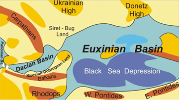
Paleogeographic reconstruction of the Eastern Paratethys connectivity just before the Messinian crisis event (after Jipa and Olteanu, 2006 |
Innovation: The proposed Black Sea project offers innovative aspects through:
- a novel integrated approach of the interplay between tectonics, sedimentation and sea level changes. The innovative part relate to a complete basin restoration setting, including the Danube system, semi-connectivity and specific sedimentation mechanisms in environments with rapid changes in salinity;
- Processing of high-resolution seismic data sets capable to determine subsurface structures and seismic facies related to fine variations in base level changes and the connection with the active tectonics triggering submarine landslides;
- quantification of sedimentary exchange between Carpathians-Danubian area and the Black Sea during the Messinian to Modern times;
- Upscale to a higher resolution of the industrial seismic data with the available and new high-resolution, shallow-seismic datasets.
Added value:
- Improving knowledge of dynamic sedimentary systems. Besides the novel understanding of the integrated evolution of past and present sedimentary budget transported in dynamic sedimentary architectures, such a model should input information on particular events such as the present-day 3D motions of the coastal zones and deltas, active tectonics and impact of vertical basin motions. The final model should allow exploring the key controlling parameters that influence the sensitive areas of the entire source to sink system, the balance between the water level evolution in the Messinian - Holocene and the (neo)tectonic framework for the Black Sea semi-enclosed basin as a major, end member receptacle for central Europe.
- Trigger future development of research activities. This CRP project creates the framework of developing high quality research; the concepts and results derived will certainly trigger national level financing a better understanding of the interplay between tectonic and sedimentary processes in the evolution of the source - carrier - sink system.
|
|
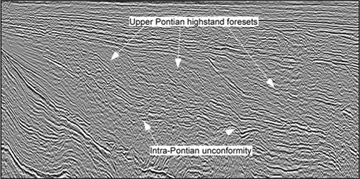
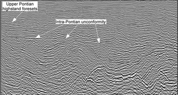
Features observed in the offshore western Black Sea coeval with the Messinian salinity crisis in the Mediterranean and not yet quantified. Note the similarities with the larger southern Mediterranean basin. (Left) Major progradation sequence over the “Messinian” (intra-Pontian) unconformity; (Right) The “Messinian” unconformity. Note that this unconformity can be studied here due to tilting of pre-unconformity strata. This is related to large landslides and normal faulting
Deliverables and/or milestones:
Assessing the generic mechanisms for the Messinian salinity crisis. The sea-level drop in the Black Sea at a moment with no apparent connectivity with the Mediterranean impose a re-evaluation of widespread sea-level drops;
- Newly processed high-resolution seismic lines with potential to underly the mechanisms for base level drop in enclosed basins;
- Interpretations of industrial seismic lines, upscale in the upper part with high resolution seismic data
- Strathigraphic correlations and an updated reference regional strathigrapy
- Maps of major discontinuities and channels distribution at different time
- Models of transport, sedimentation and active tectonics during sedimentary processes
- Integrated model of interplay between tectonic framework, sea level changes and sedimentary processes
References:
- Dinu, C., Wong, H.K., Tambrea, D. and Matenco, L., 2005. Stratigraphic and structural characteristics of the Romanian Black Sea shelf. Tectonophysics, 410: 417-435.
- Jipa, D., 1997. Late Neogene-Quaternary evolution of Dacian basin (Romania). An analysis of sediment thickness pattern. Geo-Eco-Marina, 2: 128-134.
- Ryan, W.B.F., Major, C.O., Lericolais, G. and Goldstein, S.L., 2003. Catastrophic flooding of the Black Sea. Annu. Rev. Earth Planet. Sci., 31: 525-554.
- Winguth, C., Wong, H.K., Panin, N., Dinu, C., Georgescu, P., Ungureanu, G., Krugliakov, V.V. and Podshuveit, V., 2000. Upper Quaternary water level history and sedimentation in the northwestern Black Sea. Marine Geology, 167(1-2): 127-146.
|
|
|
