 |
SourceSink |
Danube Basin Geosciences |
 |
|
| © 2008 by SourceSink consortium - all rights reserved |
Aims and objectives: We aim to develop a 3D dynamic computer model of the joint tectonic and sedimentary evolution of the entire Danube system to integrate and better understand the outcomes of SourceSink. This model will test the consistency between observations at lithospheric-scale (tectonic) and surface-scale (basin sedimentology and geomorphology) and will provide a process-based understanding of the Danube Basin evolution since the Eocene.
Such computer algorithm will be capable of incorporating the main large-scale tectonic processes generating topography together with existing simulation techniques of erosion and surface sediment transport. The resulting simulations will account for the sedimentary budget between sedimentary sinks and orogenic sources. It will facilitate the interpretation of existing and new data in a quantitative and geodynamic way, as well as the large-scale linkage between the observations at the subdomains of the system. The modeling results will tell us also about the relative importance of long-term tectonic uplift/subsidence in the orogens and basins and sedimentary overburdening in defining the drainage history of the Danube, which will provide a regional framework to hazard assessment in other IPs. For example, the periodical floods affecting historically the central Pannonian Basin must be studied in the context of the long-term competition between tectonic and fluvial processes creating and filling the basin.
Innovation: The proposed modeling technique has never been applied at such large scale involving 3 orogens and 4 separate basins; only an initiative such as this CRP can put together the different data required for modeling this vast drainage basin including 15 national territories in Europe. The development of 3D finite difference models of coupled crustal deformation and surface sediment transport is a forefront international challenge in understanding the interplay between surface and deep processes.
Added value: Bringing together the data on geomorphology, thermochronology, sedimentology, geophysics and tectonics of the vast study area, as required to fine-tune the models proposed here, is hardly imaginable out of the context of a network such as SourceSink. Inversely, the added value this IP will bring to the whole CRP is creating a geodynamic model capable of integrating all those separate results. The outreach tasks will provide a multidisciplinary and forefront synthesis of the geological processes affecting the topographic and drainage changes of the study region, for both scientists and the general audience.
Outreach: Taking advantage of the position of this IP within SourceSink, we also aim to improve the visibility of the project and to bring SourceSink motivations and results closer to society and accessible for a broad audience. This key interaction with the rest of the CRP will facilitate feeding an ad-hoc web site that will transmit to the broad audience the mechanics of an alive research project and the strategies being applied to better understand the geological controls on hazards.
Methodologies/experiments: The numerical model is the result of a combination of algorithms simulating surface-processes and tectonic deformation. For the erosion/sedimentation we will use stream power laws to simulate river incision and diffusive equations for hillslope processes. These will be linked to existing dynamic models of lithospheric-scale extensional and compressional tectonics using the thin sheet approach (vertically averaging the lithospheric rheology). Calculations will be performed in finite difference with a rectangular Eulerian mesh. Although part of the technique is already developed (Garcia-Castellanos, 2002; Jimenez-Munt et al., 2005), and is part of the background of the GDL (Group of Dynamics of the Lithosphere) in the ICTJA-CSIC-Barcelona, a first task of this project is to perform code improvements required to adapt to the specificities of the Danube scenario. This includes allowing boundary conditions with simultaneous extension and compression, and complex orographic distribution of precipitation. A second task of the project consists of compiling existing and ongoing data from other IPs within SourceSink.
|
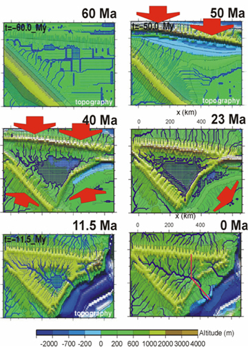
Top view of results from numerical modeling of the Ebro Basin, using a technique similar to the one proposed in this IP. Each panel shows a stage of the continuous topographic and drainage evolution calculated by the computer program. Red arrows show the imposed tectonic shortening. These results are constrained with the sedimentary budget, tectonic cross sections, and paleoclimatic observations. From Garcia-Castellanos et al., 2003. |
Deliverables and/or milestones:The results from this individual project will provide the tools for filling the temporal and spatial gaps in the geological record of erosion and transport in the Danube Basin. The results will provide a geodynamically consistent imaging of the topographic and paleogeographic evolution of a vast area of Central and Eastern Europe from a process-based perspective and the development of its largest drainage system. The developed computer programs will remain available for future research dealing with the interaction between tectonic and surface processes in other regions.
|
|
|
