| © 2008 by SourceSink consortium - all rights reserved |
Problem statement: Geodynamic development and structure of the Western Carpathian lithosphere in connection with its impact on the formation of geo-relief and occurrence of geo-hazards should be investigated by comprehensive multidisciplinary approach. Such approach is crucial for deeper understanding of all processes leading to landscape evolution in time and space. Model of past denudation and depositional history can help in prediction of present environmental risks and is a principal part of the synthetic geo-hazards evaluation.
Aims and objectives:
- Geophysical properties of the Carpathian – Pannonian lithosphere, geodynamic interpretations of structure and development, definition of possible relationships between deep lithosphere structure and geo-relief evolution in time and space.
- To develop a new model of morpho-lithosystems evolution of the Western Carpathians and adjacent basins (“regional level” in scale 1: 5 000 000); on the basis of source areas and their thermal history, architecture of basins sedimentary fill, geomorphological markers, as well as composition of the lithosphere based on geophysical data. Evolution of landscape in time interval Late Miocene to Quaternary
- Creation of integrated model of land surface evolution in the western part of the Carpathians (“core area” in scale 1: 500 000); Slovak part of the Danube and Vienna basins, Malé Karpaty, Považský Inovec and Tribeč Mts. for particular time intervals (Upper Miocene – Pliocene – Quaternary – present day) that will serve to quantification of local budget of source and sink relationships. Denudation and accumulation linkages will be studied in more detailed scale (1: 50 000) in selected areas, in intra-Quaternary time intervals (e.g. catchment of Studený potok creek in the High Tatra Mts. - the most dynamic part of the West Carpathians, Myjavská pahorkatina hilly land with exceptional gully erosion).
- Geohazard assessment will be realized in two groups: natural and environmental hazards determined structurally and climatically. Methods of synthetic evaluation of geohazards will be improved by evolutionary models results and morphotectonic field evaluation. Delimitation and definition of comprehensive hazardous regions in case study area will be performed using the GIS technology. Case study area of synthetic hazards regionalisation will be the Western Carpathians and their close hinterland. High resolution methods of determination and evaluation of natural hazards solved in other partners of the Source & sink project.
Methodologies/experiments: Multidisciplinary approach of individual project will be based on simultaneous and coordinated using of various geophysical, geological and geomorphological methods. The study of problems in the various scales (from 1: 5 000 000 to 1: 50 000) and time intervals (from Upper Miocene to Holocene, inclusive present day stage) enable continual transformation of results from the local to regional scale.
Geophysical research will be based on preparation of integrated maps of lithosphaere thickness, crustal thickness, heat flow map, pre-Neogene basement contour map, Bouger anomaly map, evaluation of deep and shallow seismic profiles, etc.
Geological research will be focused on structural pattern development, paleostress field analysis, basin analysis including accumulation rates, sedimentary architecture, depositional environment and sequence stratigraphy approach. Uplift rates of source areas will be estimated by low thermal dating methods (FT - fission track analysis).
Geographical study will use traditional geomorphological markers (river terraces, longitudal profiles, surfaces of planation, …) and reinterpreted it in process of modelling. However, the main tool will be the GIS technology applied to landform analysis in various scales.
Creation of a specific geomorphological GIS based on elementary forms conception will be effective tool for detailed quantitative analysis of processes of denudation and accumulation in the Pleistocene – Holocene stage. Application of isotope geochronology (thermo-luminescence dating, cosmogenic isotope dating and so on) can bring time framework needed for calculation of erosion and deposition effects.
Innovation: Quantitative analysis of morphological network (regular network of remarkable morphological boundaries) will be specially elaborated. Morphometric analysis will lead to develop and use a methods of (semi)automated delimitation of morphological network and its evaluation by multivariate statistical methods. Results together with specification of geophysical (seismic, gravity, etc.) and geological (paleostress and paleostrain) fields will be used for definition of the morphotectonic field character.
Investigation of eventual planation in the conditions of extensive tectonic (formation of tectoplane) can bring reinterpretation of older regional geomorphological theories and contribute to more real construction of denudation-sedimentary budget of the region.
Synthetic characteristics of hazards and definition of comprehensive geo-hazardous regions is innovative approach based on the analysis of mutual relations of the most marked geo-hazards, the spatial structure of combinations of extreme values of various hazard types from the viewpoint of their possible synergetic operation and multiplication effect.
Added value:
- Deeper understanding of landscape evolution by synthesis of geophysical, geological and geographical approaches. Modern morphometric analysis enable define morphological fields that are a consequence of influence of the deep Earth and climatically conditioned processes on georelief. Synthesis morphological, geophysical and geological fields that reflect a synthetic influence of various evolutionary factors can define the morphotectonic field.
- Identification and explanation of territorial differentiation of integral influence of main geo-hazards. Formation of integral geohazardous regions (characterized by various combinations and interrelations of particular geohazards) is probably determined by morphotectonic field evolution. Demonstration of statistically significant linkages between empirically delimitated regions and construed morphotectonic field should confirm the hypotheses and enable extrapolation of hazard significant information.
- Education. The project results will be implemented into the undergraduate and graduate education process, particularly as far as the actualisation of knowledge in lectures of regional geology and geography is concerned.
- Propagation and popularisation. The UNO has declared triennium 2007–2009 with the central year 2008 as the International Year of Planet Earth, with the catchword “Earth sciences for society”, hence focusing also on popularization of geosciences in the human society. The IYPE activities will be utilized also for propagation of the project results.
Work plan:
General work plan including structure of cooperation in framework of collaborative research project is depictured in the following figure:
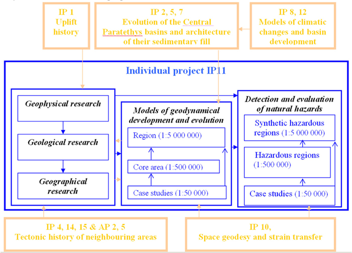
Models of geodynamical evolution in various scales (middle block) followed by natural hazard detection and evaluation (right block) will by developed as a result of interdisciplinary approach (left block).
Planed cooperation and exchange in scope of the Source & sink project can be specified:
- Mutual fieldworks and exchange of the FT analysis specialists between VU Amsterdam and CU Bratislava. Fieldworks in the Western Carpathians, sampling and following laboratory analysis in Amsterdam, common interpretation of achieved results, publication. Planed duration of field works 3 weeks, 4 researchers, and 3 MSc or PhD students. Planed duration of stay of Slovak participant in VU Amsterdam laboratory is 3 month;
- Evolution of the Central Paratethys basins, architecture of their sedimentary fill synthesis and models of basin and orogene relief development as well as climatic changes will be developed during bi- and multilateral short term fieldworks, workshops and information exchange between cooperating partners, approximately 6 weeks, 4 researchers and 3 PhD students/postdocs;
- Workshop organisation by IP 11, spring 2011 in the High Tatras Mts.: High resolution methods of hazards detection, evaluation and regionalization.
Deliverables and/or milestones:
Geophysical maps: lithosphere thickness, crustal thickness, heat flow map, pre – Neogene basement contour map, Bouger anomaly map, evaluation of deep and shallow seismic profiles
Core area geodynamic model of evolution (Vienna and Danube basins, Malé Karpaty, Považský Inovec and Tribeč Mts.): structural pattern development, paleostress field analysis, basin analysis including accumulation rates, sedimentary architecture, depositional environment and sequence stratigraphy approach.
- Uplift rates of source areas estimated by low thermal dating methods (FT - fission track analysis).
- Regional model of landscape evolution and relief building processes in Western Carpathians
- Synthetic hazardous regions of the Slovakia.
- Workshop organized by IP 11: High resolution methods of hazards detection, evaluation and regionalization
|


